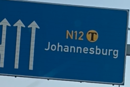
When driving from Johannesburg, you’ll find yourself navigating the N12, N4 and R40 to get to Phabeni & Paul Kruger gates via Hazyview.
Recommendation: Do not drive this route after dark
For safety reasons, and to fully appreciate the scenery en route to KNP, daytime travel is strongly recommended.
Do not enter KNP through Numbi gate.
What Road Conditions Can I Expect?
- The N4 and N12 are major national highways that connect Johannesburg and Pretoria to Kruger Park’s South and South Eastern gates.
- This is also a major trade corridor towards Mozambique, expect to pass large transportation trucks along the route.
- The R40 is a picturesque single lane provincial road that’s generally well-maintained, though it includes winding sections.
- The highways are typically well-maintained and meet similar standards as those found in more developed countries.
- The exception to this rule is highway lighting. The majority of the route is unlit. Even areas passing through cities have inadequate lighting.
N12 Conditions
The Johannesburg to Emalahleni (Also known as Witbank) N12 segment is a multilane highway that offers a smooth and straightforward driving experience (~138km)
N12 Map Between Johannesburg and Emalahleni
This is what the N12 looks like near Emalahleni:
N4 Conditions
The N4 is a well maintained toll highway with three toll plazas between Emalahleni and KNP.
→ Please see this guide – Toll Plazas on the Road to Kruger: What to Expect for more on this topic.
Emalahleni to Machado Toll Plaza
The Emalahleni to Machado Toll Plaza segment of the N4 is a Multilane highway offering a smooth and straightforward driving experience (~113km).
N4 Map Between Emalahleni and Machado Toll Plaza area
This is what it looks like just before it turns into a single lane highway:
Machado Toll Plaza to Nelspruit/ Mbombela
From the Machado Toll Plaza onwards the N4 becomes a mostly single lane highway with intermittent overtaking lanes strategically placed to facilitate passing slower vehicles (~90km to Nelspruit).
→Please see this post on overtaking on single lane highway/ road
Between the Machado Toll Plaza and a few KM’s before Nelspruit/ Mbombela, the N4 branches into two:
- N4 North via Schoemanskloof (R36).
- N4 South (N4)
Your navigation app might suggest taking the Northern N4 route via Schoemanskloof. This route tends to shave a couple of minutes off your trip when compared to the southern route. If you take the either route, you’ll be fine.
- Worth noting: On this segment of the route, you should expect to encounter many large transportation trucks.
- You must be patient and wait for safe overtaking opportunities.
- Depending on the mood of the truck driver in front of you, they may even indicate, slow down, and pull to the side of the highway to let you pass.
N4 Map after the Machado Toll Plaza area
This is what the N4 looks like as a one lane highway:
R40 Conditions
The R40 connecting Nelspruit to Hazyview is mostly a single lane provincial road with intermittent overtaking lanes strategically placed to facilitate passing slower vehicles (~60km).
- Maintain a safe speed and stay vigilant for frequent speed limit changes. Police often conduct speed traps along this route.
- Waze is effective in detecting speed limit changes, but remain alert and watch for official speed limit signs.
- The route passes through small towns, so anticipate pedestrians and vehicles near the roadside.
- You should also be aware that the R40 passes through wildlife and farming corridors.
- Keep an eye out for livestock or wildlife on the side of the road.
R40 Map Between Nelspruit and Hazyview
This is what the R40 looks like:
Avoid The R538. Use the R40 instead.
After White River, you have the choice to continue towards Hazyview using either the R538 or the R40.
Do not proceed on the R538 from this point onward.
While the R538 is considered safe between MQP/Kruger Mpumalanga International Airport and White River, from White River it passes through local townships known for higher crime rates on the way north to Hazyview.
As with driving on any local roads in South Africa, it’s essential to remain vigilant, but it’s better to avoid the R538 altogether.
Map Highlighting the difference between the R40 and R538 North of White River.
R536 Conditions
The R536 is a single lane provincial road of average quality. It’s not as well maintained as the other roads mentioned in this article. Watch out for pedestrians, livestock, and potholes.
- The route passes through small towns, and eventually terminates at Paul Kruger Gate.
- Stay particularly vigilant for wildlife on this road, as you’re traveling through rural South Africa, right along the edge of a national park that’s larger than many countries.
- Use Waze, people use it to report hazards or other activity on the road.
R536 Map between Hazyview and Phabeni/Paul Kruger Gate
This is what a pothole looks like on the R536:
Other Local Roads
- Rural roads have varying road conditions, including potholes, gravel sections, or narrow passages.
- Drive cautiously and adjust your speed accordingly.
- Be aware that local roads may pass through farming/wildlife corridors. Keep an eye out for livestock or wildlife on the side of the road.

